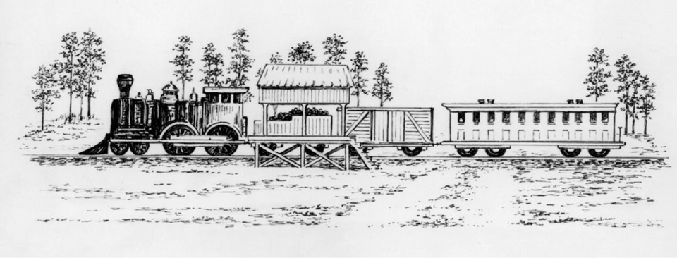
Pen and ink sketch by Jane Jackson
as depicted in “Village to City Florence SC 1853-1893” by E. N. Zeigler.
During the early 1850’s The Wilmington & Manchester Railroad was under construction. Once completed, the Wilmington & Manchester would connect the small midland South Carolina village of the Manchester to the port city of Wilmington, North Carolina. Construction began on the new line in 1849 from both of its ends. Sometime during late 1852 the construction crew from the Manchester side reached the pine forest 9 miles south of Darlington. It was in this pine forest that a station was established at the intersection of the W&MRR line & the road to Darlington so that passengers could make the stop to nearby communities and plantations. This station holds historical significance in the story of Florence as it was the first of its kind in the area, and more importantly the station’s presence was integral to developments in the local railroad industry that helped birth our city.
The first known documentation of the station appears in a North Eastern Railroad document titled, “The Report of the President and Chief Engineer of the North Eastern Rail Road of South Carolina” from 1852. This report makes mention of the station in Darlington District as “James’s Station”. The accompanying map issued with the NERR report also labels “James Station” near the intersection of the Wilmington & Manchester Railroad and the Cheraw & Darlington Railroad. The first known published mention that refers to this area as “Florence” appears in chapter nine of the book “Sketches and Reminiscences”. Joshua Hilary Hudson writes…
“I was elected and on January 6, A.D. 1853, left Chester for Bennettsville. I spent the first night in Columbia by the South Carolina Railroad, I traveled to Kingsville, where I took the train of the Wilmington and Manchester Railroad and traveled as far as Florence, which was then a station in the pine forest without a depot, a rough board shelter being the only accommodation for passengers getting on and off there….”
These two references offer us a few great insights. The 1852 NERR document informs us that the general location of the station was in fact at Florence (indicated on the map by the words “James Station” written near the intersection of the W&MRR and the C&DRR lines). The Hudson account gives a first hand description of how the station appeared in its early days. It is described as “a station in the pine forest without a depot, a rough board shelter being the only accommodation”. These two accounts offer important information on the historically significant local station, but these accounts still leave us with questions:
- Where was the station’s exact location at Florence? James Station could’ve been located anywhere along a 4 mile stretch of the Wilmington & Manchester line between Ebenezer & McCown’s Crossing.
- Was James Station the only station of its kind at Florence? The evidence doesn’t suggest that Hudson’s station was in fact the same James Station from the NERR map.
An exhaustive search for documents (such as maps, surveys, plats, deed records, etc…) contemporary to the existence of the station has proven unsuccessful in providing definitive answers to the questions above. It is more than likely that the NERR map’s James Station and the Hudson account of the ‘rough board shelter’ are referencing the same station at Florence. Though the search failed to turn up any corroborating proof, a newspaper ad for the Sleepy Hollow Hotel (well known among local historians) does provide a few more clues in regards to the station.
The Sleepy Hollow Hotel

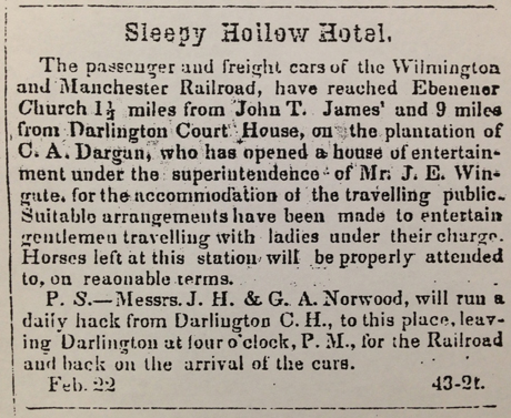
An ad in the Marion Star Newspaper dated February 22, 1853 documents the use of a Florence station by the W&MRR.
The Sleepy Hollow ad informs us of quite a few things concerning the railroad. It informs us that by late February of 1853 that the Wilmington & Manchester Railroad had reached at least as far as (if not further than) Ebenezer Church, and the railroad was running its passengers and freight cars along the western length (Manchester to Florence) of its incomplete road. The ad also confirms the existence of a local station, but unfortunately it doesn’t specify a location or a name for the mentioned station. The station is only mentioned in passing, but the focal point of the ad’s historical intrigue seems to be the “Sleepy Hollow Hotel” itself. According to the ad’s description, the hotel would have been located somewhere on the property of C.A. Dargan. The ad also seems to indicate that Ebenezer Church was on the property of C.A. Dargan. This give us a general starting point for locating the Sleepy Hollow Hotel. Further research at the Darlington County Historical Commission linked the Dargan family to a plantation named “Sleepy Hollow” located in Darlington District. An 1852 newspaper ad from the Darlington Flag was also found at the DCHC. In this ad posted by C.A. Dargan, a plantation described as being “situated on Jefferies Creek” is listed for sale. The final piece of evidence suggesting an exact location of the Sleepy Hollow Hotel was the discovery of an 1854 Colton’s map of South Carolina observed at ReNewell Inc. Conservation in Columbia SC. A detail from the 1854 Colton’s map of South Carolina shows the location of the plantation of C.A. Dargan at the Junction of Ebenezer Road and Jefferies Creek. This location fits the description given in the Sleepy Hollow Hotel Ad. Based upon the totality of this research, it is likely that the Sleepy Hollow Hotel existed as guest rented rooms in Sleepy Hollow plantation or some other building on the plantation property of C.A. Dargan located at the junction of Jefferies Creek and Ebenezer Road.
In addition to showing the location of the property belonging to C.A. Dargan from the Sleepy Hollow Hotel ad, the 1854 Colton’s map of South Carolina also depicts the location of a “Florence Station” at the intersection of the Wilmington and Manchester Railroad and Hoffmeyer Road. In all likelihood, the Florence Station of the 1854 Colton’s Map and the James Station of the 1852 North Eastern Railroad Map are one in the same. The station was probably called “James Station” before the name “Florence” was adopted by 1853. Tradition states that “Harlleeville” and “Wilds” were a few of the names considered for the pine forest where the station was located. The name “Harlleeville” was considered in honor of W&MRR president, William Wallace Harllee. The name “Wilds” was also considered as to honor the prominent local judge, Samuel Wilds. In the end, neither name was chosen. The name “Florence” was chosen in honor of Florence Henning Harllee, the daughter of William Wallace Harllee.
Locating the Sleepy Hollow Hotel and James Station
This map was compiled using the information from the documents referenced through out this article.
Click on the map markers to learn more!
If you would like to learn more about the history of Florence, check out the following sources used to help author this post:
Books:
Rise Up So Early A History Of Florence County South Carolina, by G. Wayne King.
Village to City Florence SC 1853-1893, by Eugene N. Zeigler.
Sketches and Reminiscences, by Joshua Hilary Hudson
Miscellaneous Resources:
Report of the President and Chief Engineer of the North Eastern Rail Road of South Carolina 1852. *
Map of the North Eastern Railroad and Its Connection to Other Railroads 1852
surveyed by Jno. Johnson & G.E. Walker. *
Colton’s Map of South Carolina 1854
surveyed by Jno. Johnson & G.E. Walker.
Sleepy Hollow Hotel Advertisement,
Marion Star February 22nd, 1853. (found at the Darlington County Historical Commission)
Plantation For Sale Advertisement,
Darlington Flag, Jan 8th, year unknown. (found at Darlington County Historical Commission)
* indicates item is located at The South Carolinana Library in Columbia SC.


